Bhutan Jumolhari Trek

11 - 14 Days
TYPOLOGIES
DIFFICULTY

Medium

MIN. AGE

12 Years

£ 3750

An Amazing Experience

This is possibly one of the most beautiful and unspoiled trekking areas in the entire Himalaya region. We trek through beautiful villages and farmland, gorges and valleys, high pasture land and passes.

On this Pioneer expedition we trek through gorges and valleys, offering spectacular views of the sacred summits of Bhutan including Bhutan’s deeply venerated guardian peak Mt Jumolhari and Jichu Dranke. We trek to lakes, high pasture land and passes and along the way we can see blue sheep and marmot and we may see a snow leopard if we are lucky.

This trek can be achieved at its very best between March and June or September to November. Please see our website or contact us for scheduled group dates. Alternatively if you are looking for a private expedition or would like to visit during one of Bhutan’s many festivals, please contact us for further information.

Higher prices for this trip occur in high season, as shown below.

Price £3,750/$4,500

Based on 2 pax. Excludes international flights.

DISCOVER MORE ABOUT BHUTAN

Upcoming Group Departures

March - November

VIEW OUR GROUP DEPARTURES

Tailormade Departures

Speak to our travel designers - All of our trips can
be designed to suit you and your dates of travel.

CONTACT US

Day by Day

Arrive at Paro. (the flight to Paro is one of the most spectacular of all mountain flights with stunning views of the Himalayas including Mt. Everest during clear weather). Upon arrival you will be met by your expedition leader and transferred to our hotel (situated in a beautiful pine forest) Following welcome drinks and lunch / dinner, we have the option of visiting the Ta Dzong ‘National Museum’ , Paro Rinpung Dzong (the location for the film ‘The Little Buddha’).

Today we make a pilgrimage to one of the most important religious sites in the Himalayas, Taktsang Goempa, known as the Tiger’s Nest. This magical monastery clings to a vertical granite cliff 2,000 feet above the valley floor.
After about 45 minutes of (moderately steep) hiking, we reach a small tea house that has a wonderful panoramic view of the temple. We can then hike another 1hr to the small chorten directly across from the temple for an even closer view.
On our return to our hotel we will visit the 7th century Kyichu Lhakhang, one of the 108 temples built in the Himalayan region over the areas of Tibet and Bhutan by the Tibetan King Songtsen Gampo. We may also have time for a quick visit to Paro town before returning to our hotel for dinner.

We transfer by road to Drukgyel Dzong, a burned shell, once a fortress strategic in Bhutan’s defence against the Tibetan invasion. Mt. Jhomolhari (24,500 feet), the sacred summit, looms above us.

This trek begins at Gunitsawa Village were you pass the army post. At the army checkpost your trek permit which we have already processed in advance will be checked and endorsed. The trail starts gradually up the river valley passing farms, stunning rhododendrons and primulas, crossing and re-crossing the river many times. After a few hours the footing becomes a little more challenging with rocks on the path and a steeper 300ft climb. Tonight we camp in a meadow in a shelter which has been built for trekkers.
Camp is in a meadow with shelter which the government had built for trekkers. There are views of Jumolhari as you reach camp which makes an excellent photo opportunity.

TREK INFO
Starting elevation: 9,482ft at Drukgyel Dzong | Elevation gain: 2,559ft
Ending elevation: 11,745ft | Distance: 11.8 miles

We set off up the Pa Chhu Pass, a small army post where the valley begins to widen again. The trail climbs to a beautiful flat plateau with a small chorten and follows the river around a sharp bend before climbing to another plateau , here we will have a hearty lunch waiting for us.
After a hot lunch of noodles and vegetables, we continue, now above tree line, through a spectacular valley lined with snow peaks and several huge waterfalls.

We pass the small village of Jangothang, and within an hour, reach the camp at the base of the ruins of an ancient fortress and (if it is clear) Jumolhari looming at the end of the valley.

TREK INFO
Starting elevation: 11,745 ft | Elevation gain: 1,647 ft | Ending elevation: 13,100 ft
Distance: 9.9 miles

Today you can decide if you want to trek or “rest”. There are stupendous day-hikes in 3 directions. Jumolhari and its subsidiary is directly west, Jichu Drake to the north, unclimbed summits and ridges to the east. For those feeling the altitude or just interested in relaxing, a great way to spend the day is by simply sitting in camp and watching the shifting light on Jumolhari.

Today’s walk is very short so it is possible to enjoy another day hike from Jangothang before heading to the lakes and the new campsite.
The trail crosses the river and begins to climb up to the lakes. A steep climb for about 45 minutes with spectacular views of Jichu Drake and Jumolhari which grow more and more impressive as you gain altitude. This is a spectacular walk with the three major peaks rising above the valley, a broad stream on your right and snow covered peaks in the distance. Once you reach the top of the plateau, the trail will level out and the first lake will come into view. Our camp will be set up between the lakes and near several yak herders’ tents which we may visit.

TREK INFO
Starting elevation: 13,100 ft | Elevation gain: 1,000 ft | Ending elevation: 14,100 ft
Distance: 4 miles

Today, we tackle the Bang Tue La (pass) which is the highest point on our trek at 15,600’. We set off early to allow for enough time to reach camp and to get over the pass in the morning when the weather is the most stable.

The trail leaves the valley floor and begins the climb to the pass with a steep traverse of a screed slope. As we approach the top of this first incline, we cross a small glacial stream. The trail winds up and into an upper valley, with snow capped peaks in the distance. We skirt several streams and a small lake as we make our way towards the final climb to the pass.

Be on the lookout for Blue Sheep on the steep hillsides above the valley. In the fall, the sheep gather in herds numbering up to 500 individuals. In addition to blue sheep, there are several snow leopards living in this region.

As we climb, we will pace ourselves to allow our bodies to adjust to the elevation. At a slow pace, we should be at the pass by approximately 11:00am. From the pass, the trail drops quickly to a huge grass covered plateau dotted with yak herders’ tent stone circles. To the right is a massive cliff with waterfall and a vast scree field below. The valley of Soi Yaksa is an incredibly scenic box canyon, which ends abruptly at the foot of the steep cliff. Above the canyon floor, the landscape is comprised of cliffs, waterfalls and higher still, snow covered peaks.

As we ramble through the steep grazing fields, we can see the edge of the plateau which ends with a final descent to the valley floor and our camp site beside a rushing stream.

TREK INFO
Starting elevation: 14,100 ft | Elevation gain: 1,576 ft | Ending elevation: 12,300 ft
Elevation loss: 3,215 ft | Distance: 8.6 miles

This morning we climb steadily for 600 feet above the camp before the trail levels out and winds around a ridge. After crossing a stream we have another steep climb to a small pass marked by several small chortens. We will stop for a brief tea break and then continue, now above tree line, past yak herder tents and herds of grazing yak. We reach the next valley which has a beautiful snow-fed river.

We cross the river and begin the climb to the pass. It is steep, but we take our time and after one and a half hours we reach our second pass, the Tahung La at 14,400’. From the pass, we can see the large valley of Thongbu and our campsite for the night – a wide valley with many yak herder encampments. A gently winding trail leads us downhill to our camp.

If the weather is good, the view from the pass is spectacular, with Mt. Jhomolhari and Jichu Drake rising over the mountain range we covered yesterday. We have a clear view of the Bong toe la (yesterday’s pass), and the Soi Yaksa valley.

TREK INFO
Starting elevation: 12,300 ft | Elevation gain: 2,132 ft |Ending elevation: 13,132 ft
Elevation loss: 1,312 ft | Distance: 6.85 miles

As we set off from camp we have a relatively short but steep climb up the side of a mountain covered with dwarf rhododendrons to a small pass. From this point, we begin a wonderful part of our trek route. For almost two hours, we walk along a ridge line trail with drop offs to the valley floors below on both sides. If it is clear, there are panoramic views of the major peaks and distant valleys. Eventually we drop down from the high ridge and we begin to glimpse views of another dramatic peak, Jho Drake Gang. Like Jichu Drake, it is the residence of a local male deity, while Jumolhari is the home of Jhomo, a female deity. We are now in an area of rocky cliffs and parapets which fade in and out of the mist. We descend further to a lovely spot with views of the valleys below us where we stop for a tea break. From this tranquil spot, we begin one of our most challenging parts of the trek. For the next three hours, we are dropping steeply on a switchback trail losing more than 4500 feet.

The trail again is littered with many stones that make footing challenging. Taking our time and (watching our knees) we descend to the valley floor. As we lose elevation, the landscape changes from alpine with dwarf rhododendrons to lush pine forests with huge ancient trees.
We reached the valley floor at Shana where we will have a hearty lunch at the King’s camp site near the army camp. After a good lunch, you are driving 2 hrs distance to Thimphu by car, where our luggage and hot showers await!! As well as a post trek celebration.

TREK INFO
Starting elevation: 13,200 ft | Elevation gain: 722 ft | Ending elevation: 9,482 ft
Elevation loss: 4,525 ft | Distance: 9.2 miles

We depart early this morning for the drive to Punakha valley. Within a few kilometres of Thimphu stands the Simtokha Dzong. Built in 1627 by Shabdrung Ngawang Namgyal (the man who unified Bhutan), it is the oldest of the Dzongs. A Fortress/monastery, it originally served as the administrative centre of the region, the center for the monks’ religious activity, and protection for the valley. Its prayer wheel alcoves contain slate carvings of Buddhist deities that date from the construction of the Dzong. Simtokha now houses the national language school.
After Simtokha, the road climbs through pine forest to 10,000 foot Dochu La (la means pass). In good weather 200 miles of Himalayan summits are in view.

We continue down the winding road to the lush Punakha valley below. The elevation is 4,500 feet, and the valley is the richest agricultural region of Bhutan. We will have a packed lunch alongside the river before continuing downstream to the dramatic Wangdiphodrang Dzong. Perched on the end on a long ridge, the Dzong commands a strategic view of three valleys. If there is time, we can wander down the main street of the village and look into the shops. By early afternoon, we will depart for the village of Punakha.

The Dzong situated at the confluence of the Pho (father) and Mo (mother) rivers guards the southern end of the Punakha valley. This huge fortress/monastery was the national capital until 1966. The Je Khenpo, head abbot of the Tibetan Buddhist church in Bhutan, and most of the monks if Thimphu occupy this Dzong during the winter, since the lower elevation of the Punakha valley (4500’) has more comfortable temperatures. Late in the afternoon, we will be on our way back over the Dochu La (pass) to Thimphu.

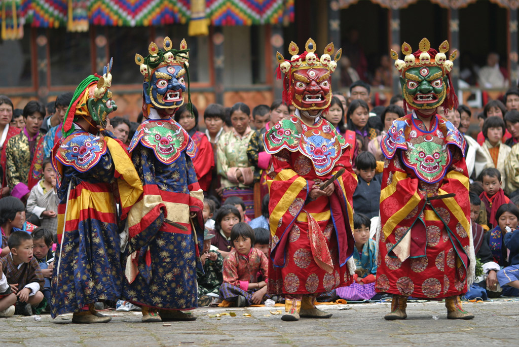
Today we are free to enjoy the sights of Thimphu in the morning. As Bhutan’s largest city, with a population of approximately 70,000, Thimphu is Bhutan’s “Big Apple”! It is the seat of the Royal Government of Bhutan, the home of the Royal Family and the main center for most international aid organizations. As the only true “city” in Bhutan, it is unique mix Himalayan and western sensibilities.

Depending on the interest of the group, visit today may also include:

1. Textile Museum: this museum was inaugurated under the patronage of Queen Ashi Sangay Choden Wangchuk in June 2001. Many intricate designs of Bhutanese textiles are displayed here. It will also serve as center for conservation, restoration and documentation of Bhutanese textiles.

2. National Folk Heritage Museum: one of the oldest house in the capital Thimphu, having been restored and transformed into Folk Heritage Museum in the year 2001 under the patronage of Her Majesty the Queen Ashi Dorji Wangmo Wangchuk and this museum is meant to serve an account of everyday rural life for the young urbanized generations and as a place for preserving objects related to this life, in case this way of life disappears as time passes.

3. Paper Factory: Visit a handmade paper workshop where artisans create beautiful and unusual handmade papers, the handmade paper industry in Bhutan stems from the age old handicraft tradition and its history can be traced back to the 8th century. Handmade papers are made out of Daphne papyri era sieb, Edge worthia papyrifera sieb and Pine apple plants. And a weaving workshop where the looms are filled with traditional and updated versions of the world-renowned Bhutanese textile arts.

4. The handicrafts Emporium: the Handicraft Center is a good place to browse through examples of Bhutan’s fine traditional arts and crafts. Here you can buy textiles, Thangkas, scenic painting, mask, ceramics, slate and woodcarvings, musical instruments, jewellery, butter-tea cups, yak tail dusters and all kinds of exotic and fascinating objects and also

5. The archery grounds (where you might catch an archery match)
In the late afternoon, we return to Paro, driving through the idyllic countryside, dotted with villages and paddy fields, crossing rivers and natural forests to Paro.

Tonight we will have a farewell dinner celebration with our staff as we enjoy our last evening in Bhutan. If you are interested, we may be able to arrange Bhutanese “stone bath” this evening.

Transfer to airport for return home. End of Expedition!

DOWNLOAD ITINERARY

Area Map

Submit your review
1
2
3
4
5
Submit
     
Cancel

Create your own review

Pioneer Expeditions
Average rating:  
 1 reviews
 by Van der Valk
Outstanding!

Outstanding natural beauty and extremely interesting cultural introduction thanks to superb guide.

    Enquire now

    Other Amazing Trips

    We are open from:

    9am

    We close at:

    5:30pm

    We are always here to help or answer any questions - call us on: 01202 798922

    Laurenne Mansbridge

    Director


    X
    Sign up to our Newsletter

    Pioneer Expeditions Newsletter

    Travel with Us